top フェリー
時刻表
Oita Himeshima Geopark
Oita Himeshima Geopark is a certified Japanese Geopark as of 2013, known as “A mysterious island formed from volcanoes”. The area of the geopark is 6km from north to south and 14km from east to west, which covers sea area centered by Himeshima island.
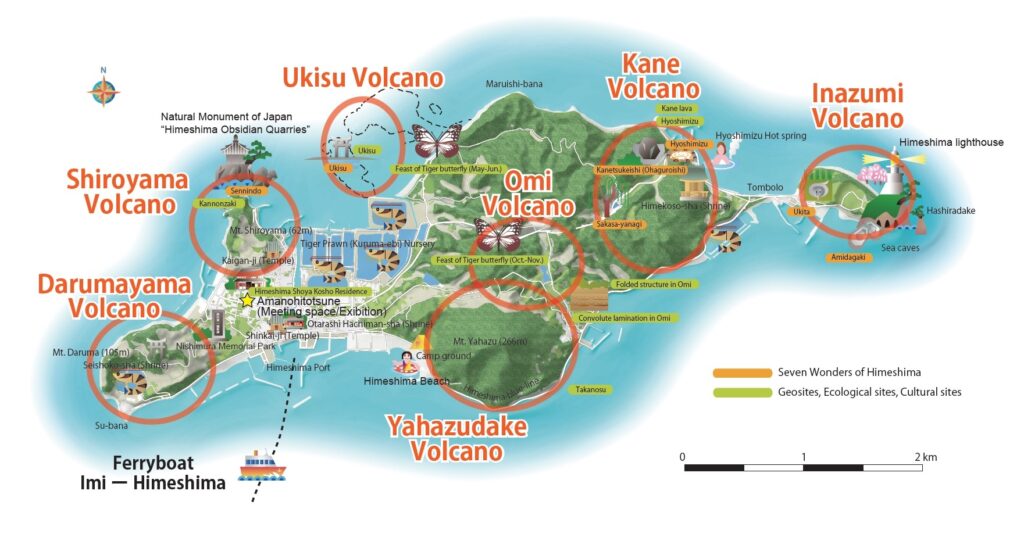
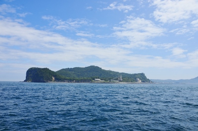
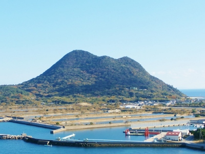
Himeshima is an island connected by sand bars, which originally consists of four islets formed from the volcanic activities of Himeshima volcanoes from about 300,000 years ago. Oita Himeshima Geopark is a compact geopark, where geosites are closely located. There are various geo-heritages such as topographic remains caused by volcanic activity, industry developed on sand bars, and a unique ecosystem. Mysterious local history, culture and traditional landscape are also attractive aspects of Oita Himeshima Geopark.
List of Main Sites
Geosites
Volcanoes
Himeshima has seven volcanoes that had been active in the past 300,000 years. Various topography generated by volcanic activities, such as lava domes formed by sticky magma and craters of phreatomagmatic explosions, can be found.
Darumayama Volcano
Mt. Darumayama was formed from volcanic activity about 120,000 years ago. Darumayama lava exposed at Subana, has a rugged surface and thus is called “Yoroi-iwa”, derived from the armor of samurai. Darumayama lava contains phenocrystic minerals such as hornblende and anhydrite.
Shiroyama Volcano
Shiroyama Volcano, located in northwest Himeshima, is characterized by vesiculated milky white lava. Parts of the Shiroyama lava is obsidian cliff which forms the beautiful scenery in Kannonzaki. The Shiroyama lava had been quarried for perlite until recently.
Ukisu Volcano
The most part of the volcanic body is subsided under waves at high tide. The reef, named “Ukisu”, is one of “the seven wonders of Himeshima” and consists of Ukisu lava and becomes attached to the mainland at low tide.
Yahazudake Volcano
Mt. Yahazudake, the highest peak of 266.4m in Himeshima, was formed from volcanic activity about 90,000 years ago. Yahazudake lava, which is dacite containing hornblende phenocryst, is distributed from hillsides to the top of the mountain.
Omi Volcano
Omi Volcano is known for its ejecta found in the area between the eastern foot of Mt. Yahazudake to Futamata Lake. The activity of Omi Volcano is the earliest among the Himeshima volcanic group, because the volcanic topography is not preserved.
Kane Volcano
Kane lava, characterized by its distinct conspicuous flow-banding, is dacite containing hornblende phenocryst. Five lava domes or shallow intrusive bodies of dacite are distributed in Kane Volcano. Volcaniclastic debris deposited during the activity of Kane Volcano can be seen along the coastal area of Kane Port.
Inazumi Volcano
Inazumi Volcano viewed from around Hyoshimizu looks a trapezoidal shape, caused by the dish-like shaped volcanic crater in the center. There is a lighthouse that stands above the cliff of Inazumi lava.
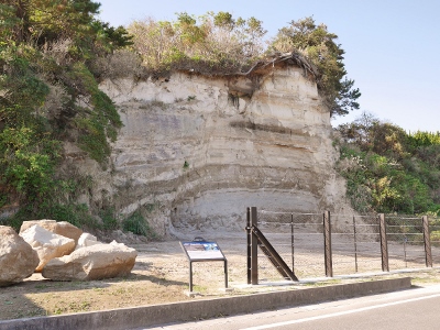
Geological formations
The geological formations found in the center part of Himeshima are fluvial and lacustrine deposits, prior to transgressing into the Seto Inland Sea. These formations, which various depositional structures are observed in, contain volcanic clasts derived from Kunisaki Peninsula and various fossils such as plants, molluscs and mammals. The strata are deformed by geological faults and folds, resulting from a subsequent uplift in volcanic activity.
Takanosu
“Takanosu” is the sea cliff located in the southeast of Mt. Yahazudake, along the road “Himeshima Blue Line”. The name means the hawk’s nest and comes from the fact that falcons nest here, using hollows on the surface of the cliff.
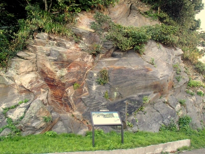
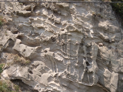
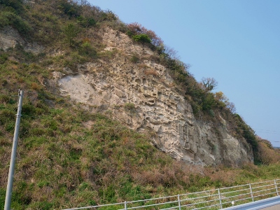
Convolute lamination in Omi (Designated Natural Monument of Oita Prefecture)
The roof-tile pattern of the cliff strata is an example of convolute lamination, a rare feature here in Oita Prefecture produced by the crumpling of strata by earthquakes. This cliff became a Designated Natural Monument of Oita Prefecture in 1959.
Outcrop of Maruishibana Formation
Largely inclined strata on the coastal line of Maruishibana, deposited about 2 million years ago, has developed various geological structures such as folds and faults.
Rocks, Fossils, Minerals and Spring water
There are various geological heritages such as obsidian found in Himeshima. The volcanic rocks of Himeshima, called rhyolite, are typically characterized by a striped pattern and have been widely used for stone walls on the island. Various resources found in Himeshima, such as elephant fossils, vivianite, and spring water are important to understand the geology.
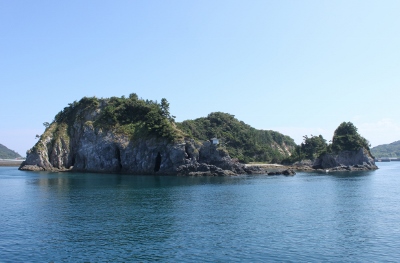
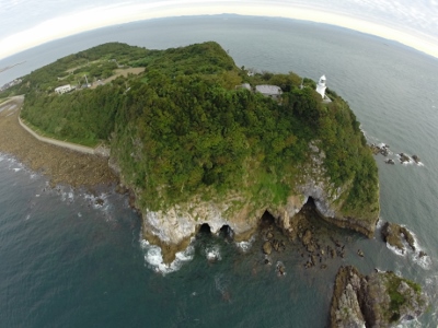
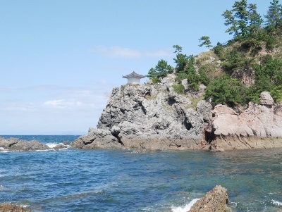
Natural Monument of Japan “Himeshima Obsidian Quarries”, Kannonzaki
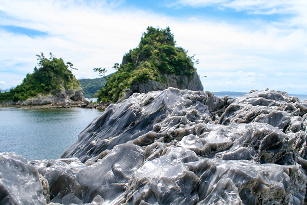
Kannonzaki, Himeshima’s most renowned beauty spot, is home to unique obsidian cliffs, ranging from a milky grey to milky white color. Obsidian in Kannonzaki is important geologically and archaeologically, because past volcanic activity is recorded in these rocks and because obsidian was used widely in stone tools around the Seto Inland Sea and across Western Japan in the Paleolithic era. For these reasons, the area around Kannonzaki was named “Himeshima Obsidian Quarries” and was designated as a Natural Monument of Japan in 2007.
Vivianite (Designated Natural Monument of Oita Prefecture)
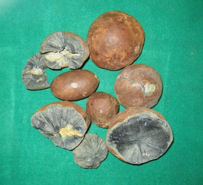
Vivianites, a kind of iron phosphate mineral, are found on sea floor at Subana in Himeshima. Vivianite found in Himeshima became a Designated Natural Monument of Oita Prefecture in 1959. Vivianites vary in shape, such as spherical or bone like shapes.
Hyoshimizu
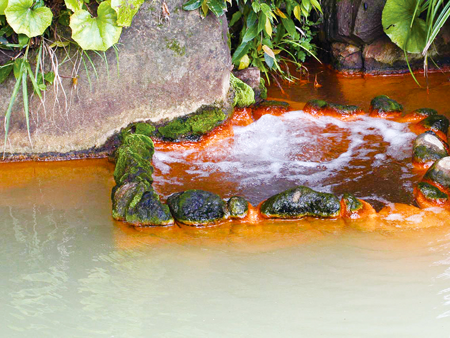
“Hyoshimizu” is a lukewarm bicarbonate mineral spring with a water temperature of 24.9℃, is continuously streaming in northeast Himeshima, and can be drunk.
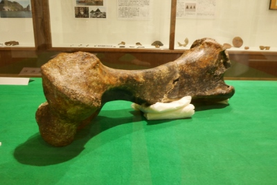
Elephant fossils
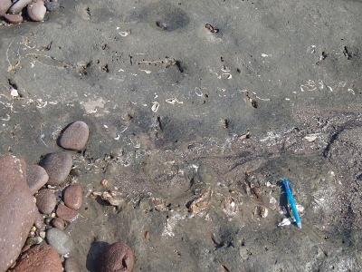
Other fossils
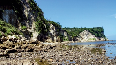
Topography
There are various landforms formed by sea erosion around Himeshima. Erosion of the basal part of the sea cliff forces the upper unstable part to collapse, and results in exposure of the new surface of the sea cliff. Differential erosion of the sea cliff creates sea caves in weaker parts of the cliff.
Tombolo
Himeshima is an island connected by a sand bar, which originally consisted of four islets. There are relics of sand bar topography called Tombolo in various parts of the island. The landform of the four islets and sandbar is easily recognized in the view of Himeshima from Kunisaki Peninsula.
Takanosu
“Takanosu” is the sea cliff located in the southeast of Mt. Yahazudake, along the road “Himeshima Blue Line”. The name means the hawk’s nest and comes from the fact that falcons nest here, using hollows on the surface of the cliff.
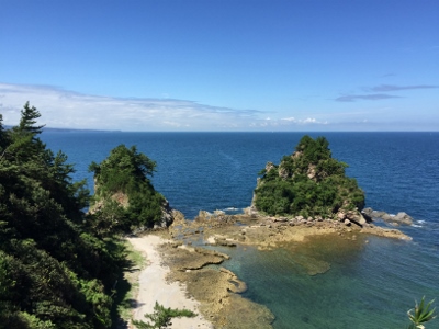
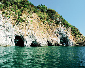
Sea cliff and sea cave in Kannonzaki
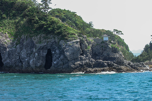
There is an obsidian sea cliff, 40m tall and 120m wide, in east side of Kannonzaki. Several sea caves can be found on this sea cliff.
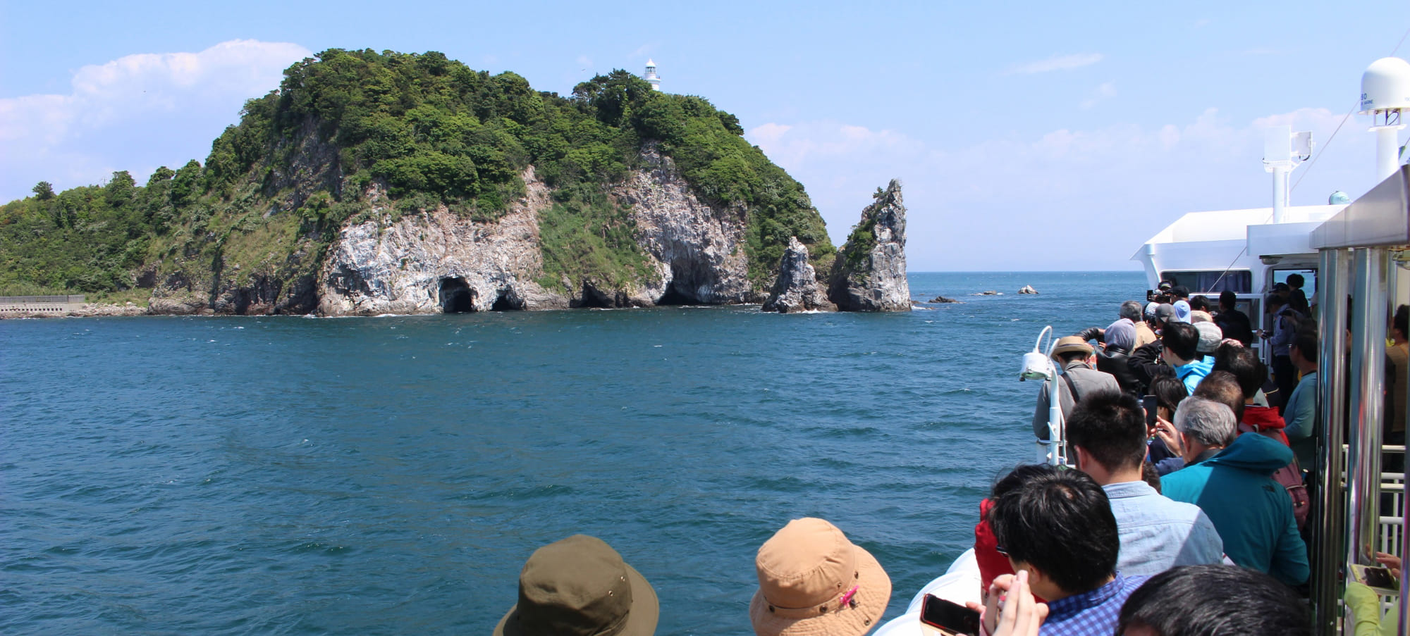
Sea caves and “Hashiradake” below the Himeshima lighthouse
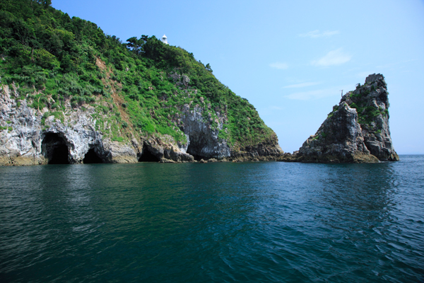
The coastal cliff exposed below the Himeshima lighthouse is composed of Hashiragadake lava, which is a part of the Inazumi Volcano. There are several sea caves on the basal part of the cliff. There is “Amidagaki”, one of “the seven wonders of Himeshima”, in the western largest cave, in which small boats can enter during a high tide. “Hashiradake”, isolated rock columns found in the eastern end of the cliff, are originally a part of the land. These columns are regarded as remains after the collapse of the roof of the sea cave.
Ecological Sites
Place for feast of Chestnut Tiger
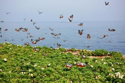
The Chestnut Tiger is a large butterfly which migrates long distances. The butterflies stop over on Himeshima from mid-May to mid-June on their way north to feast on the nectar of Sunabikisou, the Siberian sea rosemary. The new generation stops over, too, when flying south in mid-October, drawn this time by Fujibakama, the fragrant eupatorium.
Nesting place for raptors
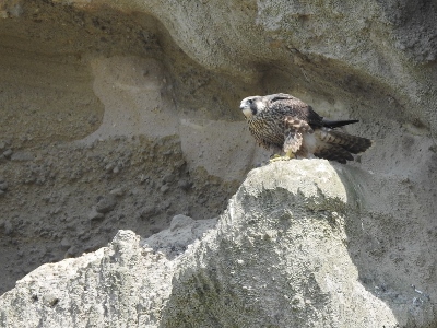
Himeshima is home to raptors such as ospreys and falcons, which are the target species for “Act on Conservation of Endangered Species of Wild Fauna and Flora”. Ospreys nest in Kannonzaki’s “Toshakuiwa” and falcons nest in the sea cliff “Takanosu”.
Plants
Natural woods of Sudaji (Designated Natural Monument of Himeshima Village)
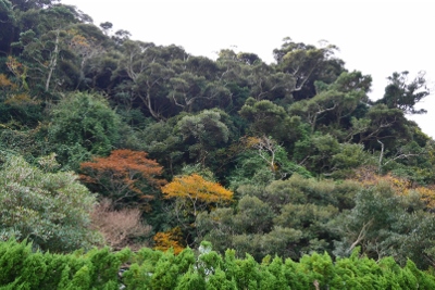
Natural woods of Sudaji (Castanopsis sieboldii) is growing around the cliffs behind Himekoso shrine.
Official village tree of Himeshima; Black pine (Pinus thunbergii)
Black pine (Kuromatsu), characterized by a lumpy black bark, is a pine native to coastal areas of Honshu, Shikoku, and Kyushu. Though Himeshima had many black pine trees until the end of Showa, it was damaged by pine wilt disease from the end of the Showa to the Heisei period. Many black pine trees have been cut down in order to prevent the spread of damage, and the number has been greatly reduced. Black pine trees that survived the damage still remain at various places on the island today.
Official village flower of Himeshima; Nojigiku (Chrysanthemum japonense)
Nojigiku was designed as the official village flower of Himeshima in 1976. It is a perennial flowering plant within the genus Chrysanthemum of the family Asteraceae that is distributed from Hyogo Prefecture to western Japan. It grows naturally on sunny beach cliffs and blooms in October to December annually.
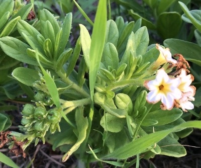
Sunabikisou, the Siberian sea rosemary
Historical and Cultural Sites
History, Culture and Industry
Yojaku archaeological site
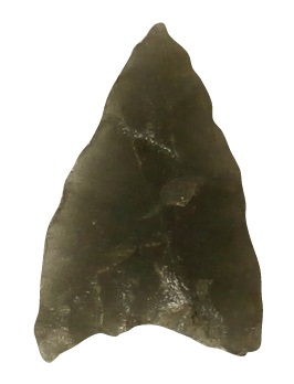
The Yojaku archaeological site is located on a flat hill, northwest of Mt. Yahazu and was excavated in 1988. Obsidian remains such as arrowhead are excavated on this site. It is considered that stone tools using obsidian of Himeshima had been produced here.
Old house of the Kosho family (Tangible Cultural Property of Himeshima Village)
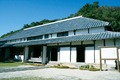
The Kosho were the Shoya (village headmen) of Himeshima during the Edo period. Their achievements included the construction of salt pans, introduction of the sweet potato crop, and building of a stone breakwater. This old house, the Koshoke, was built by the 11th head of the Kosho family, Shigetoshi Kosho, in 1842. The 1,800m2 site contains both the main building and a post office built in 1904. The main building has a hipped roof and partial upper story with a combined floor area of about 430m2. The whole property, including the traditional landscaped garden and Onari-no-ma room for receiving high-ranking visitors, was designated as a Tangible Cultural Property of Himeshima Village in 1990.
Natural Monument of Japan “Himeshima Obsidian Quarries”, Kannonzaki
Kannonzaki (Shimonoseki Bombardment and Himeshima)
The Choshu clan of what is now Yamaguchi Prefecture shelled foreign ships passing through the Kanmon Strait at Shimonoseki in May, 1863. The multinational squadron of 17 warships from Britain, the United States, France and the Netherlands gathered in Himeshima Nishiura in August, 1864 for a retaliatory mission. The squadron sailed from here to bombard the batteries of Shimonoseki. Hirofumi Ito, Kaoru Inoue and Kaishu Katsu, historical persons of Japan, had come to Himeshima because of this incident.
Himeshima Lighthouse
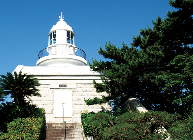
Himeshima Lighthouse, constructed from granite, was built above the cliff on eastern end of the island in 1904. It was electrified in 1963 and automated in 1945. The view from here expands over the Seto Inland Sea, and the mountain ranges of Shikoku and Chugoku on a clear day. Lighthouse Park is most famous place for its cherry blossom on the island. There is a heart-shape stump of Oshima cherry in this park, which the spirit of the legendary princess entered.
Stone breakwater “Okinohato”
Volcanic rocks in Himeshima have been used for rock walls and stone breakwaters which are important for people’s life. “Okinohato” is the oldest stone breakwater in Himeshima, built in 1841. Stone materials used for “Okinohato” are mainly lava from the Shiroyama volcano in Himeshima.
Relics of the salt industry and Cultivation of Japanese tiger prawns
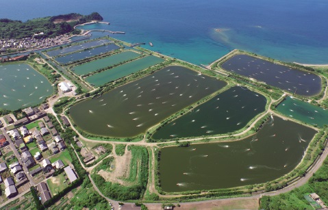
Salt fields had been operated from the 1500s to 1959, using tidal flat on sand bar in central Himeshima. The relics related to the salt industry remain in various places around the salt fields. Cultivation of Japanese tiger prawns begun in 1963 using the original salt fields and has now become a core industry for the village alongside coastal fishing.
National Intangible folk cultural property“Himeshima-no-Bon-Odori (Traditional Bon dance in Himeshima)”
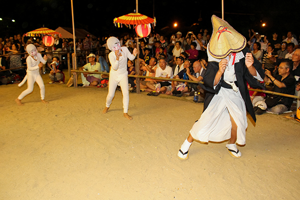
The Bon dance of Himeshima is thought to have been derived from the Nembutsu dance in the Kamakura period. There is a traditional dance and a creative dance. It is held over three days from August 14th to 16th every year, in which the first two days are especially busy. “Himeshima-no-Bon-Odori” was designed as a National Intangible folk cultural property in 2012.
Seven Wonders of Himeshima
Sennindo
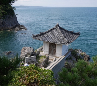
Sennindo is the little Buddhist hall on Kannonzaki. Bato Kannon, the horse-head form of Kannon, the Goddess of Mercy, is enshrined here. Sennin means a thousand people and the name reputedly comes from a saying that on New Year’s Eve, the time of year when debts are settled in Japan, it is able to provide refuge for 1,000 good people fleeing their cruel creditors.
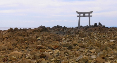
Ukisu
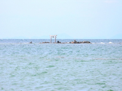
Ukisu is an offshore small reef, at which fishery’s sea god Takabe-sama with torii is worshiped. Ukisu means floating shoal, the name reputedly comes from a saying that it never soak in sea water even when it is an exceptionally high tide or waves during severe storm.
Sakasa-yanagi
Sakasa-yanagi means upside-down willow tree. It is said that after using a willow twig as a toothpick to blacken her teeth, the Princess stuck the toothpick upside-down in the ground by a nearby pond. Where the Princess stuck the toothpick into the ground the toothpick budded and consequently grew upside-down.
Kanetsukeishi (Also known as Ohaguroishi)
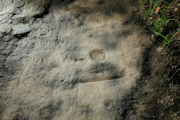
This flat stone which is approximately 3.3 square meters in area is said to be the location where the Princess set down a choko (a small cup) and a brush to blacken her teeth. A common practice married women would do during the Edo period. Consequently, the impressions of the choko and the brush have been left in the stone where she set them down.
Hyoshimizu
Hyoshimizu means hand-crapping water and is a sacred spring that the Princess is said to have created. The myth says that after having blackened her teeth, she rinsed her mouth and where there was no water; she clapped her hands and prayed to the heavens. From between two rocks a spring was formed.
Ukita
Under a patch of damp ground is Ukita, literally meaning floating field. This is where a male and female snake lived. According to one myth, this is where the islanders had killed and buried the female snake. It is said that the act of the spirit of the big snake is the apparent cause of the field moving.
Amidagaki
There are several sea caves on the basal part of the cliff exposed below the Himeshima lighthouse. In these sea-level caves, oysters form in the shape of an Amida Sanson Buddha. Eating these will anger the gods and cause one to get sick.